Iron Mountain Peak Trail
Tuesday, October 13th, 2009 We hiked Iron Mountain Peak Trail last in July with my niece, Anna. Even though it was early morning with a temperature in the 70s, Brandy overheated and we had to cool her off with our drinking water. We met a hiker on the way down that gave us directions to the spring, but we just couldn’t find it.
Today was in the 60s and overcast. Last evening, there was a sprinkle – the first of the season- so no longer did I have to eat Brandy’s dust! We started at the Iron Mountain Peak trailhead, undecided at that point whether to hike Ellie Lane Trail or all of Iron Mountain Peak Trail. We headed up Iron Mountain Trail to the “T”, at the last moment deciding to continue to the Iron Mountain peak.
We soon overtook a hiker with an older black Lab puppy off-leash. Brandy snarled a little when they met, as she is apt to do. Quickly, however, Brandy began running — her tail down and ears back — as fast as she could up and down the trail around the puppy. She exhibits this running behavior frequently at dog park, presumable to get other dogs to chase her. After a few laps, she approached the puppy (now we knew its name was “Cody”) and started playing.
We went on ahead, but soon Brandy stopped and wouldn’t obey, “Let’s go!” Cody caught up, they played a little and Cody continued on ahead. We swapped who was leading a few times and eventually we went on ahead to the peak.
When we were at the peak last July, the telescope was missing. Now there was both a telescope and new mailbox with a log. The first entry in the log was October 9 and it was already over half filled. We made a log entry, took a few pictures and soon Cody and Richard arrived at the peak.
Richard and I talked while Brandy and Cody played essentially at our feet. I “always” have Brandy on leash when we are hiking, but they were having such a good time playing that I thought it safe to remove the leash and give Brandy more freedom. Brandy and Cody played hard, wrestling in the dirt and chasing each other, all the time staying somewhat close to Richard and me.
After a while, play was over when Richard and Cody descended and Brandy and I ate a quick lunch at the picnic table. We then took our last pictures and headed down.
Richard had told me how to find the spring, and with his accurate instructions, I found the spring on the way back. I marked it on my GPS so I could put it on our trail map for a future hike. The spring is roughly 0.15 miles up the mountain from the helipad spur trail. Brandy took a cooling dip and then we continued down the mountain.
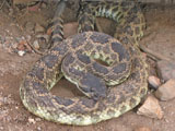
There are two porta-potties side-by-side at the Wild Horse Trail junction. I stepped inside, letting the leash go through the doorway, and closed the door when I heard Brandy saying, “Grrrrrr!” I opened the door and saw her looking at the ground while growling. She does that, sometimes at bugs and sometimes at leaves. I decided “bug” and shut the door, holding the leash. I could hear Brandy continuing to growl. When I opened the door, Brandy was still growling and then I heard, “zzzzzzz!” right next to me. Under the threshhold of the next porta-potty was a coiled rattlesnake! We were so fortunate that I picked the right porta-potty and that Brandy has good snake instincts.
I looked up and down the trail to see if there were any hikers; there were none. I then found a branch to poke at the snake to get it to move. The snake stayed motionless as I poked at it a bit, so I just left it alone, hoping it would go on its way before any other hikers come along.