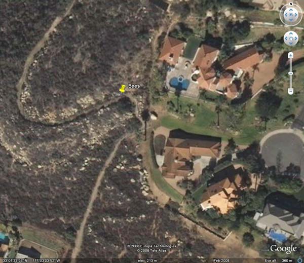
Archive for the 'Trails' Category

Bees

Tuesday, December 30th, 2008

Yesterday afternoon, we hiked Poway’s Western Ridge Trail that runs at times along the border of Poway and San Diego. We were hiking from the south and paused to enjoy the view just as we reached the top of the hill (Google Earth). I heard a buzzing sound that I recognized as bees but wasn’t focusing on it as I was taking in the view. Finally, I looked to see where the bees were and then I saw that I was by a hive in the rocks with an entrance just a few feet from me. I watched a bit as the steady streams of bees entered and left the hive and then we moved on. Brandy had been patiently waiting.

We then hiked to where the trail starts to decend and then turned around. Brandy, of course, wanted to continue. I promised her that we would hike the trail the following day. We passed the bees again on the way back and then I thought about reporting them to those in Poway who maintain the trails. The bees weren’t bothering me (if fact, I like the interest they add) but I know that some people are allergic to bee stings.

Today, we hiked the Western Ridge Trail from the north where the trail begins at Old Winery Road. We went over the hill and found that the bees were still there and as friendly (no stings!) as before. I understand that tomorrow someone from Poway will be evaluating the bees.

Lake Ramona

Friday, December 5th, 2008

We set out this morning to explore the east end of Blue Sky Trail. We found several spurs at the end and investigated most of them which are ultimately blocked by Ramona Municipal Water District “No Trespassing” signs. One trail petered out by what appeared to be the remnants of small stone buildings, perhaps houses, and we didn’t try to extend the trail. We met a runner on one of the trails, stopped briefly and discussed the extent of the various trails. We were all on these trails for the first time.

We returned to the junction that leads to Lake Ramona and decided that we would attempt that. I’d been on it before with Goldie, but never with Brandy. It was a pleasant hike up with Brandy once leaping toward an almost vertical dropoff while presumably chasing a lizard. I quickly pressed the thumblock on the leash and caught her in midair bringing her back to the shoulder of the road. Otherwise, she would have stopped at 26 feet, the leash length, and I would have had to drag her back up the hill.

We finally got to the top of the dam and explored a bit. To the right (south?) was a private road obscured by a hill and we went as far as we could. We went across the dam, taking a few pictures of the view, and then decided to explore a bit more. I knew from the trail map that there was a proposed trail that was to connect to Old Coach Road and was trying to find the Lake Ramona end. There were several trails and trail branches and we randomly took one of them. We quickly reached the top of a hill and could see parts of Old Coach Road and a couple of roads or trails nearby to the north that might be viable. We’ll plan to explore those next time. We understand that a new trail map is in the works. (Here’s a temporary link to the current trail map.)

We then returned to Blue Sky Reserve and about half-way back I saw a small snake stretched out on the road. Brandy either didn’t see it or just ignored (not likely!) it. It was about three-eights inch in diameter and almost three (est) feet in length– a very skinny snake. I stepped around it and then it occurred to me that there might still be rattlesnakes around. I had expected that the snakes would not be active and felt comfortable hiking close to the brush along the trails. I’ll rethink that!

The trail that was damp and firm earlier in the day was dry with the ball-bearing-like DG making descent a challenge, especially when Brandy would extend the leash to the end and give me a tug to help me along.

I offered Brandy water numerous times but she refused all but once and drank very little. It seems strange that she drinks so little water on our hikes.

Stoneridge Trail

Tuesday, December 2nd, 2008

We began at the west end of Stoneridge Trail. This brought back memories of Amber, who first introduced me to this trail and which is one of my favorites. We made it almost to the open area to the east when we met a lady with a German Shepard and a Golden Retriever. She had stopped on the trail constricted with two fences and I signaled that we would move off the trail in an open area while they passed. She insisted that we proceed, which we did. Suddenly, she was being pulled by her dogs toward us and unable to stop them. I don’t believe that she could have stopped even one of them from pulling her as these dogs were big. I was concerned that Brandy might snarl and start a fight, even though the dogs seemed friendly. Fortunately, she, the dogs and I milled around for a moment and then Brandy and I were able to pass with no snipping or snarling.

We went past the houses, hiked a few minutes in the open space and came to a small trail that led toward the creek. We thought we’d take the small trail and a couple of minutes later Brandy stopped and placed her body across my path. I stopped and moved slowly ahead. She gave a little but still kept her body crosswise to the path. I thought that maybe she sensed something ahead so deferred to her, returning to the main trail.

Shortly we came to Sycamore Creek and met up with Old Coach Trail. We took it to the left, toward Highland Valley Road. After a climb up the steep hill, we took a spur that was used to reset the power poles and then returned to the main trail. Once again Brandy put her body across my path. I moved away from her back the way we had come and she quickly moved ahead of me. I thought I’d reverse direction and once again she moved in front of me and blocked me. Once again, I deferred to her and we continued back across Sycamore Creek.

When we started up back up the hill we saw a smaller trail off to the left and took that. It was a pleasant walk along the creek and then back up the hill but at a more gentle slope. This trail was the same one that we had previously started on that from the main trail; it was just a bypass. Brandy didn’t seem to have a problem with using it from the other end.

We came upon some shrubs with white bumps and no leaves. Upon closer inspection, the white bumps were flower buds just beginning to open. I think we’ll come back in a week or so and enjoy the flowers!

We uneventfully completed the hike.

Mt. Woodson

Wednesday, November 26th, 2008

Brandy and I left from our home intending to go past Lake Poway toward Mt. Woodson on the Mt. Woodson Trail or the Warren Canyon Trail (depends on the map one is using) to where the trail “T”s. When we got to the T, we thought we’d go on a little further. Finally, we came to a Mt. Woodson Trail sign with an arrow showing the way, and decided to see how far we could go. The trail was very well maintained but very steep with numerous switchbacks. Signs of the Witch Creek fire were everywhere.

Eventually, we came to another T and to the left we could see someone on a large (20 – 30 feet?) boulder at a peak and who was throwing rocks off it. We thought that we would go to the right because it seemed like the correct way to Mt. Woodson summit. We couldn’t see the antennas but trusted our instincts. As we proceeded toward the peak, we eventually were passed by a group of six young people. A few minutes later we saw them ahead and one person was standing at the edge of Potato Chip rock. From my perspective, the rock was so thin that it wouldn’t support its own weight. We continued on past them and soon made it to the summit. What a view! And no camera! 🙂

We stayed at the peak briefly, long enough to determine what we thought was the highest ground. There were two huge boulders that were higher still but we couldn’t find a way to the top of them. We returned much more quickly that we had ascended and I was beginning to get exhausted about a half mile from Lake Poway. I thought about calling Shirley to pick us up at Lake Poway, but as we were now walking on more level terrain I regained a bit of energy. We left Lake Poway and completed our walk back home. What a day! Enjoyable!

Statistics
Home to Mt. Woodson summit: 2.0 hours
Mt. Woodson summit to home: 1.5 hours
Elevation gain/loss: 2145 feet (Google Earth)
Lake Poway staging area to Mt. Woodson summit: 3.3 miles
Home to Lake Poway staging area: 1.3 miles
Total distance: 9.2 miles
Total time: 3.5 hours

Another coyote

Saturday, November 1st, 2008

This afternoon we took an early hike in our neighborhood instead of going to RB Dog Park.  We thought we’d go down by the creek to get a little closer to nature. We explored around the old stone houses and then turned around and went downstream. We crossed a tributary and then Brandy caught a scent. It wasn’t on the ground, but in the air and she was following it very agitated with her head held up. I saw the coyote first and a few seconds later she saw it. She pulled hard on the leash and I stopped to keep her back. She whined in both protest and eagerness to get to the coyote. I shortened the leash so the coyote wouldn’t try for dinner. The coyote was rather thin. I looked around to see if there were any others and found none. The coyote walked into the brush and we hiked back to Summer Sage, warily looking for other coyotes.

Tooth Rock

Saturday, November 1st, 2008


Tooth Rock

Tooth Rock


Brandy and I are looking for a Poway Adopt-A-Trail Program trail to adopt, but apparently all the trails near us have already been adopted. So, this morning we thought we’d look at Tooth Rock Trail as we’d never been on it. The first issue was determining where the trail started off Golden Sunset Lane. The street ended in a cul-de-sac with what appeared to be four private driveways. Eventually, we found a trail sign about a hundred yards up one of the private drives. Once on the trail, we found it easy to follow because we knew the general direction of Tooth Rock, even though we couldn’t see it.

The trail was generally covered with very fine dust that made little clouds as we walked. The terrain appeared to be “rattlesnake country” and didn’t look like a place we’d like to hike in the summer. We thought that we wouldn’t adopt this trail. The trail met a wider trail (a very narrow road?) and we went right toward Tooth Rock. As we walked, the dust became decomposing granite and the trail began climbing. The decomposing granite acted as ball bearings under my shoes and I struggled somewhat, but Brandy didn’t seem to have a problem with it.

We finally made it to Tooth Rock. The air was clear and we could see far and wide. After enjoying the virtual 360 degree view, we decided to return.

On the way back I missed the narrow trail at the junction of the wider trail on which we were hiking but Brandy picked it up. It was nearly hidden in the brush and could be seen easily only when next to it.

We noticed the log waterbars placed across the trail to control erosion and found about 8 places when the logs had burned in the Witch Creek fire and all that was left was the rebar stakes meant to hold the logs in place.

We returned to the trailhead, meeting only a couple of dogs barking on the other side of the fences.

Ouch!

Wednesday, October 29th, 2008

Shortly after returning to Summer Sage from the coyote experience, Brandy was walking strangely with her body lowered. I thought that she was perhaps on the trail of a coyote. However, after brievly watching her, I saw a sand burr on her left, rear paw pad. I raised her leg, pulled out the burr and felt the the pad. I found a piece of the burr which had broken off in her pad. She let me work with her without complaint. The piece of burr was so short that I couldn’t get it out with my fingernails, so I picked her up and carried her home. As I came in the door, I called for Shirley to get the tweezers. I gently put Brandy on her side, took off my glasses (I have microscopic vision without my glasses), and pulled out the piece of burr. Brandy got up and was just fine.

As she was shortchanged on the previous hike, we took off again on a different hike, along the San Diego aqueduct.

Coyotes

Wednesday, October 29th, 2008

We took our daily morning hike,  this time to the open space by the creek and remanants of old stone houses that are about a block away from our home. The access is a small creek that flows from under Summer Sage and that has trails on each side. The southerly trail is fairly wide and open while the northerly trail is very narrow and squeezed between the relatively dense foliage between the trail and the creek on one side and five-foot wood and chain-link fences on the other side.

We chose the narrow trail this morning and had just started down the trail when Brandy, on a 26′ leash, darted into the brush and I lost track of her. She was growling and tugging on the leash. Suddenly, she reappeared from the brush and ran down the trail. I decided to humor her and ran after her as she helped by pulling me along. We came to a clearing, she slowed and then I saw the lone large coyote, about 50 yards away, moving slowly away from us. We stopped briefly and the coyote stopped. We advanced toward the coyote and it moved away from us, keeping its distance.

We decided that there might be other coyotes nearby and Brandy weights about 27 delicious pounds, so we crossed the creek to take the southerly trail back to Summer Sage. The coyote was stopped, looking at us as we lost sight of it as we walked past the brush and trees between us and the coyote. When we got on the other side of the brush, there was either another coyote or the one we saw was paralleling us as we hiked. We found the southerly trail and took it, uneventfully, back to Summer Sage.

We frequently hike that “open space” because it is interesting with several very small creeks lined with trees and brush, open areas, pools, a dam, many gopher holes and the remnants of the old stone houses. Recently, we’ve heard the coyotes making a kill almost every evening. The coyotes seemed to have disappeared after the Cedar fire, although the Cedar fire, unlike the Witch Creek fire, didn’t come very close to us. We’re glad to have them back, but do want to be careful.

While walking (without a dog) on Summer Sage one morning several years back, I met two single coyotes and one group of three coyotes all of which were in the street. All five kept their distance of maybe 50 to 100 feet and just moved out of my way into side yards as I walked. I was a little nervous about the three together, and was looking for a tree to climb or a fence to jump. Fortunately, I needed neither.

Back to the trails

Friday, September 12th, 2008

Brandy resumed hiking the Poway trails a few days ago. We’re only slightly concerned about rattlesnakes and are keeping to the wider trails in the more densely populated areas. The horses and hikers have beaten the decomposed granite to dust so snake tracks should be easy to see. The hikes don’t burn much of Brandy’s energy so we still plan to go to Poway Dog Park most every evening.

Warren Canyon Trail

Wednesday, May 14th, 2008

We are exploring the trails a little at a time with the goal of going from Lake Poway to Mt. Woodson peak. We’ve several times been around Lake Poway and now wanted to explore Warren Canyon. We started at Lake Poway Trail (counter-clockwise) with Brandy being at times after a good start, a little hesitant to continue around the lake. Brandy would stop briefly and just look at me, then, she would continue because I didn’t stop. I thought this slightly strange behavior as she almost always hikes in front of me, except for her “sniff” stops.

We took a short break where Lake Poway Trail joined Warren Canyon Trail and then continued uphill on Warren Canyon Trail along the canyon. Brandy kept stopping and starring at me. I had to keep encouraging her to continue with “Let’s go!” and she reluctantly and briefly complied. We kept hiking uphill until we met Mt. Woodson Trail and there we stopped for a short rest and to look at the scenery.

That was a far as we intended to go today, with the thought of next time we would hike from Lake Poway to the top of Mt. Woodson. We then went downhill toward Lake Poway and Brandy led the way tugging slightly on the leash.

When we got to the Lake Poway staging area, I offered Brandy water and she lapped a few times and seemed disinterested so lack of water wasn’t the issue. When we go to the top of Mt. Woodson, we’ll have water and snacks.

I kept trying to understand Brandy’s reluctance to hike as she is usually very eager to do so. I’m very interested to see how she reacts the next time we hike.

Learning the trails

Sunday, April 27th, 2008

On Espola TrailBrandy is learning the Poway trail system beginning with those trails that are conveniently accessed from her home. She’s going out at least twice daily and experiencing either a new (to her) trail or a new segment of a trail she previously hiked.

Because of the Santa Ana, Brandy was out early today to avoid the heat. This was her first experience in riding in a car since she came to her new home and she cowered when asked to jump in the car. That was strange as there was no problem in her getting in the car at the Helen Woodward Animal Center. Brandy allowed herself to be picked up and placed in the car but she immediately wanted to crawl out. She quickly settled down for the short ride to the trail head at Lake Poway Road.

Brandy explored the Espola Trail, meeting a few other dogs, joggers, rabbits and cyclists. She responded well to all, and even said “Hello” to a couple of dogs. Brandy’s learning to wait at street crossings.

Brandy cowered again when asked to get into the car and let herself be picked up. Brandy has a vet appointment on Wednesday and needs to see the car as, at least, a most-times good experience. We’ll drive her to the Rancho Bernardo Dog Park and more distant Poway trails until she realizes that we are not taking her away.